Hostel Bana — hostel in the “Basse-Terre” area, in Guadeloupe. The nearest beach is about 700 m away as the crow flies. Nearby: Carbet Falls (≈ 7.5 km).
At a glance
- Type
- Hostel
- Address
- Route de Mont Plaisir
- Area
- Basse-Terre
- Coordinates
- 16.00582, -61.60214
Location
- Beach
- ≈ 700 m as the crow flies — Plage de Salée-Bananier
- Airport
- ≈ 30 km as the crow flies — Pointe-à-Pitre (PTP)
- Nearest sight
- Carbet Falls — ≈ 7.5 km
Orange dot: the property; green and blue dots: sights and beaches nearby. Map © OpenStreetMap contributors. Coordinates are approximate.
Around the property
A restaurant and a food shop are within 600 m: you can manage day to day without a car.
- Restaurants
- 2 within 1 km; nearest: Kalinago Carbet, ≈ 540 m
- Cafés and bars
- nearest: Snack-Bar Cafe, ≈ 2.0 km
- Supermarkets and grocery shops
- 2 within 1 km; nearest: Bananier Market, ≈ 510 m
- Bakeries
- nearest: La Toque, ≈ 510 m
- Doctor, clinic or hospital
- nearest: Centre hospitalier de Capesterre-Belle-Eau, ≈ 710 m
- Bus stops
- 6 within 1 km; nearest: Bananier, ≈ 510 m
- Marina
- nearest: Port de Bananier, ≈ 460 m
- Viewpoints
- nearest: ≈ 610 m
Straight-line distances based on OpenStreetMap: the actual route is longer, and a business missing from the map is not listed here. Check opening hours locally.
Things to see nearby
All sights on the island →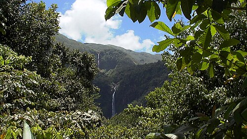 Hike
Carbet Falls
Guadeloupe's most famous waterfall, along a built path through the forest≈ 7.5 km
 Hike
La Soufrière from Bains Jaunes
A climb to the highest point in the Lesser Antilles through cloud forest≈ 7.9 km
 Beach
Pompierre beach
A sheltered cove on Les Saintes with goats and iguanas≈ 15 km
 History
Fort Napoléon
A 19th-century fort with a cactus garden and a view of the bay≈ 15 km
 Hike
Le Chameau on Terre-de-Haut
A climb to the highest point of Les Saintes, to the tower and a panorama of the bay≈ 16 km
 Hike
Cascade aux Écrevisses
A short walk to a waterfall beside the Route de la Traversée≈ 21 km
Tours nearby
All tours on the island → Guided hikes
Climbing La Soufrière with a guideAn active volcano, 1,467 m: fumaroles and a view over the archipelago
4–5 hDrier December — May; start early in the morning≈ 6.7 km
 Canyons and thrills
Canyoning and rivers of Basse-TerreJumps, abseils and swims in forest gorges
Half a dayDecember — May≈ 13 km
 History and towns
A day on Les SaintesBy ferry to Terre-de-Haut: the bay, Fort Napoléon and Pompierre beach
A full dayAll year≈ 15 km
Photos and reviews
There is no free photo of the property itself: those on Booking, Google Maps and hotel websites are protected by copyright, so we cannot reuse them. Photos of the property and guest reviews are on its Google Maps listing and on booking platforms.
Other places to stay nearby
The whole area: Basse-Terre →


Where this data comes from
This property comes from OpenStreetMap (n6423982431), where it was added by the project's contributors. Accommodation data comes from OpenStreetMap: the list is incomplete and may lag behind reality. We do not sell stays and do not know prices: check availability, rates and reviews through the links to booking platforms.
Spotted a mistake? Fix the entry directly in OpenStreetMap: the correction will appear here at the next update.